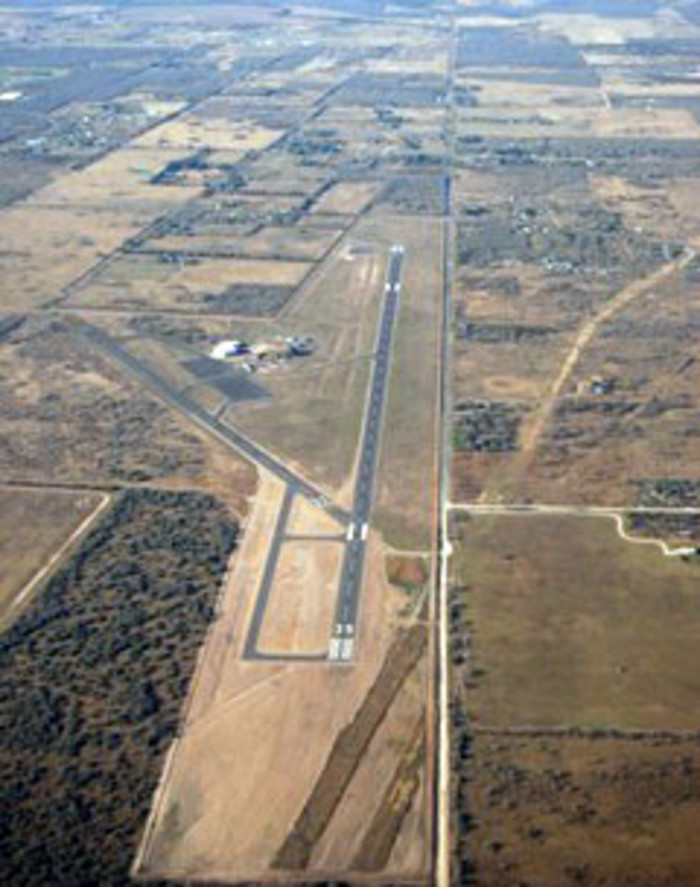
Brooks County Airport
Falfurrias, Texas
FAA INFORMATION
EFFECTIVE 06 FEBRUARY 2014
EFFECTIVE 06 FEBRUARY 2014
Falfurrias, TX 78355
Phone:(361) 325-2909
Photo by Bond Cosby
Location:
FAA Identifier: BKS
Lat/Long:
27-12-21.6868N / 098-07-15.7352W
27-12.361447N / 098-07.262253W
27.2060241 / -98.1210376 (estimated)
Elevation: 113 ft. / 34 m (estimated)
Variation: 06E (2000)
From city: 2 miles SE of FALFURRIAS, TX
Time zone: UTC -6 (UTC -5 during Daylight Saving Time)
Zip code: 78355
Airport Operations
Airport use: Open to the public
Activation date: 09/1949
Sectional chart: BROWNSVILLE
Control tower: no
ARTCC: HOUSTON CENTER
FSS: SAN ANGELO FLIGHT SERVICE STATION
NOTAMs facility: BKS (NOTAM-D service available)
Attendance: MAR-OCT MON-FRI 0900-1600, NOV-FEB DAYLIGHT HOURS
FOR ATTENDANT AFT HRS CALL 361-325-2909.
Wind indicator: lighted
Segmented circle: yes
Lights: MIRL RY 17/35 PRESET LOW INTST, TO INCR INTST & ACTVT PAPI RYS 17 & 35 - CTAF.
Beacon: white-green (lighted land airport) Operates sunset to sunrise.
Airport Communications
CTAF/UNICOM: 122.8
WX AWOS-3: 118.125 (361-325-4055)
KINGSVILLE APPROACH: 119.9
KINGSVILLE DEPARTURE: 119.9
- APCH/DEP SERVICE PROVIDED BY HOUSTON ARTCC ON FREQS 128.15/350.3 (KINGSVILLE RCAG) WHEN KINGSVILLE APCH CTL CLSD.
Nearby radio navigation aids
| VOR radial/distance | VOR name | Freq | Var |
| ALIr183/(32.5) | ALICE VOR | 114.50 | 06E |
| NDB name | Hdg/Dist | Freq | Var | ID | |
| BROOKS COUNTY | at field | 353 | 06E | BKS | -... -.- ... |
|
KLEBERG COUNTY
|
178/24.1 | 347 | 06E | TKB | - -.- -... |
| HEBBRONVILLE | 099/34.4 | 266 | 07E | HBV | .... -... ...- |
| SANTA ELENA | 033/38.1 | 260 | 07E | SNE | ... -. . |
Airport Services
Fuel available: 100LL JET-A
Parking: tiedowns
Airframe service: NONE
Powerplant service: NONE
Bottled oxygen: NONE
Bulk oxygen: NONE
Runway Information
RUNWAY 17/35
Dimensions: 6002 x 75 ft. / 1829 x 23 m
Surface: asphalt, in good condition
Weight bearing capacity: Single wheel:
52.0, GROSS ENGINEERING WEIGHT 60000 LBS. (PER AMGR)
Double wheel: 80.0
Runway edge lights: medium intensity
RUNWAY 17
Latitude: 27-12.876970N
Longitude: 098-07.207532W
Elevation: 111.9 ft.
Traffic pattern: left
Runway heading: 174 magnetic, 180 true
Markings: nonprecision, in good condition
Visual slope indicator: 4-light PAPI on left (3.00 degrees glide path)
Runway end identifier lights: yes
Touchdown point: yes, no lights
Obstructions: 34 ft. tree, 1024 ft. from runway, 24:1 slope to clear
RUNWAY 35
Latitude: 27-11.885917N
Longitude: 098-07.205567W
Elevation: 111.7 ft.
Traffic pattern: left
Runway heading: 354 magnetic, 360 true
Markings: nonprecision, in good condition
Visual slope indicator: 4-light PAPI on left (3.00 degrees glide path)
Touchdown point: yes, no lights
Obstructions: none
RUNWAY 14/32
Dimensions: 3071 x 60 ft. / 936 x 18 m
Surface: asphalt, in good condition
Weight bearing capacity: Single wheel: 4.0
RUNWAY 14
Latitude: 27-12.540675N
Longitude: 098-07.515115W
Elevation: 108.8 ft.
Traffic pattern: left
Runway heading: 143 magnetic, 149 true
Markings: basic, in good condition
Touchdown point: yes, no lights
Obstructions: 16 ft. tree, 230 ft. from runway, 120 ft. right of centerline, 1:1 slope to clear
+10 FT TREES 100-185 FT FROM THLD 100 FT RIGHT OF CENTERLINE.
RUNWAY 32
Latitude: 27-12.104055N
Longitude: 098-07.227130W
Elevation: 111.6 ft.
Traffic pattern: left
Runway heading: 323 magnetic, 329 true
Markings: basic, in good condition
Touchdown point: yes, no lights
Obstructions: none
Airport Ownership and Management from official FAA records
Ownership: Publicly-owned
Owner:
BROOKS COUNTY
CO COMMISSIONERS COURT
FALFURRIAS, TX 78355
Phone 361-325-5604
OR 361-325-5676.
Manager:
BOND COSBY
PO BOX 556
FALFURRIAS, TX 78355
Phone 361-325-2909
Airport Operational Statistics
Aircraft based on the field: 4
Aircraft operations: avg 98/week *
Single engine airplanes: 3
88% transient general aviation
Helicopters: 1
12% local general aviation
* for 12-month period ending 20 March 2011
Additional Remarks
- 9 FT FENCE LCTD APRXLY 900 FT NORTH OF RY 17.
- EXTREME NOISE SENSITIVE AREAS TO THE NORTH, WEST AND SW OF ARPT ALONG LAKE/RESIDENCE AREA.
NOTE: All procedures below are presented as PDF files. If you need a reader for these files, you should download the free Adobe Reader.
NOT FOR NAVIGATION. Please procure official charts for flight.
FAA instrument procedures published for use between 6 March 2014 at 0901Z and 3 April 2014 at 0900Z.
IAPs - Instrument Approach Procedures
-
RNAV (GPS) RWY 17
download (181KB) -
RNAV (GPS) RWY 35
download (184KB) -
NDB RWY 35
download (164KB) -
NOTE: Special Alternate Minimums apply
download (20KB) -
NOTE: Special Take-Off Minimums/Departure Procedures apply
download (105KB)
FBO, Fuel Providers, and Aircraft Ground Support
Business Name:
Mabo, Inc.
Mabo, Inc.
361-325-2909
Fuel Prices:
100LL Jet A
FS $5.99 $5.15
Updated 10-Mar-2014
